A network of ancient Roman roads converges neatly with satellite images of the Earth at night. A heat map of 15th-century bubonic plague outbreaks bears an eerie resemblance to Europe’s early COVID-19 hot spots. Mapping Past Societies, a free digital atlas hosted by the Initiative for the Science of the Human Past at Harvard, illuminates just a few of these patterns.
“It has a rich dataset of historic, economic, archaeological, environmental, and health information as well as climate data going back much further,” said Santiago Pardo Sánchez ’16, the project’s co-managing editor. “Someone who’s interested in modern transportation could look at how it worked in the past. Someone who’s looking at the plague in Central Asia could also get data from the Middle East.”
Heat map of 15th-century bubonic plague outbreaks (click to enlarge).
Credit: MAPS
Heat map of 15th-century bubonic plague outbreaks (click to enlarge).
Credit: MAPS
Heat map of 15th-century bubonic plague outbreaks (click to enlarge).
Credit: MAPS
Mapping Past Societies, or MAPS, is powered by vast spreadsheets that geo-locate everything from historic rat populations to medieval marketplaces and Roman military structures. Its user-friendly interface, which runs on ArcGIS software, invites discovery by layering multiple phenomena across a single map — or by animating how one dataset plays out over time.
“The shipwreck data have been important to me and other economic historians,” said MAPS founder and general editor Michael McCormick, the Francis Goelet Professor of Medieval History and chair of the Science of the Human Past initiative. “They offer a rather crude but nevertheless rich indicator of economic activity for the period between about 500 B.C.E. and 1500 C.E.”
For much of his career, McCormick focused on the history and archaeology of the fall of the Roman Empire. He was once in the habit of hand-drawing maps for his classes. Then a thought occurred one evening in the 1990s while he was outlining the Roman Empire for an exam: “At this very moment, around the globe, there are probably 100 other professors drawing exactly the same map,” he recalled. “I said, ‘Wait! This is not a good use of our time. There should be one map!’”
Soon he was experimenting with geographic information systems to design his own digital maps, with several appearing in “Origins of the European Economy: Communications and Commerce, A.D. 300-900” (2002). That led to partnering with the Center for Geographic Analysis to launch the free Digital Atlas of Roman Empire and Medieval Civilizations in the mid ’00s. Over the years, DARMC was slowly expanded to incorporate new datasets. Information on the ancient and medieval worlds remains most robust, but more recent additions cover Colonial Latin America, 18th-century France, and more.

Michael McCormick (from left), Santiago Pardo Sánchez, and Alexander More.
Kris Snibbe/Harvard Staff Photographer
The pandemic inspired the team to refresh the project’s branding and interface, relaunching DARMC earlier this year as MAPS. The site’s new dashboard will be familiar to anybody who recalls tracking COVID cases on the Johns Hopkins website. At the same time, recent software updates enabled the addition of that showstopping layering feature.
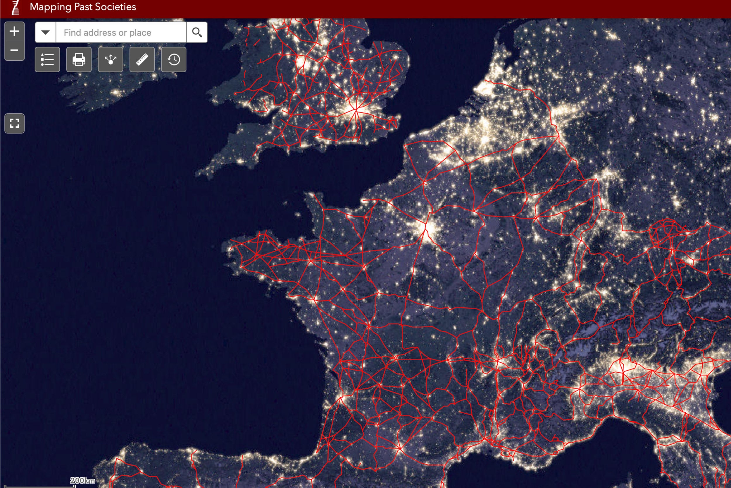
“Before you could just turn on and off one layer,” Pardo Sánchez noted. “But now, you can do much more. You can change the visualizations with overlays and transparencies. You can share it more easily. You can switch the basemap, or background, to satellite imagery of the Earth at night.”
From the start, students have been key to the project’s success. Undergraduates bring a natural fascination with Roman and medieval history, McCormick said, but many struggle to make meaningful early academic contributions in the field, given the need for proficiency in multiple languages including Greek, Latin, Arabic, and Syriac — not to mention all the must-read secondary literatures in German, Italian, French, and Spanish.
To work on MAPS, however, all they need is curiosity, attention to detail, and facility with spreadsheets. “This is a real intellectual contribution to our understanding of the human past which they can, should, and do cite among their publications,” McCormick said.
“My litmus test has been: Could a nerdy 12-year-old use it? Because if a nerdy 12-year-old can use it, then anybody can.”
Anika Liv Christensen, MAPS research assistant
“The undergrads working on the project now are younger than the project,” quipped Pardo Sánchez, who made his first MAPS contributions as an undergraduate, cataloguing findings from McCormick’s “Origins of the European Economy.” As an undergraduate concentrating in history, Pardo Sánchez later contributed to one of the site’s biggest datasets, nearly 60,000 records of climate events over the past 2,000 years.
Today, Anika Liv Christensen ’26, a research assistant currently working on MAPS, says, “It was the perfect job for a 19-year-old with no experience. Originally, my job was to check databases for errors. With so many entries, there are bound to be misspellings and formatting problems.”
Christensen, a joint concentrator in music and human evolutionary biology, recently worked on inventorying atypical burial sites in medieval France, currently with about 300 entries (each with up to five individuals per site).
“My litmus test has been: Could a nerdy 12-year-old use it?” Christensen said. “Because if a nerdy 12-year-old can use it, then anybody can.”
The enormous spreadsheets that populate the site’s map are freely available for download to anybody with an internet connection. The information on Roman roads has proved especially popular, McCormick shared. “There was a whole series of economic studies on 21st-century Europe showing that proximity to Roman roads helped predict economic vibrancy today.”
At a recent MAPS kickoff event, co-managing editor Alexander More, M.A ’07, Ph.D. ’14, an associate professor of environmental health at the University of Massachusetts, demonstrated what it looks like to plot the Roman roads alongside information on bubonic plague outbreaks from the 14th century.
“You can really see the data come alive,” he marveled. “For the first time, you can see the progression of this pandemic throughout Europe, with these hotspots emerging at nexuses of Roman roads.”
As bursts of yellow covered Italy and France, yet another historic intersection came into view. “These nexuses are in fact also the same places where COVID emerged in full force in 2020,” More said.
Source link