In a remote area of the Siberian tundra, dotted with low trees and shrubs, there’s a place that locals call ‘The Gateway to Hell.’ During the summertime, the sound of water pouring over the cliff sides is interrupted every so often by the boom and crash of falling earth. “It’s quite noisy” says Julian Murton, a geologist at the University of Sussex in England who has visited the site as part of his research. Those ominous sounds feed into Indigenous Yakutian peoples’ wariness surrounding the vast pit. In some ways, the fear is warranted.
It may not be a portal to another realm, but the ‘gateway’ or Batagay Crater is an unsettling mark of our own changing world. And, in a sense, the formation is an opening to a hidden subsoil dimension, just a scientific–not supernatural–one.
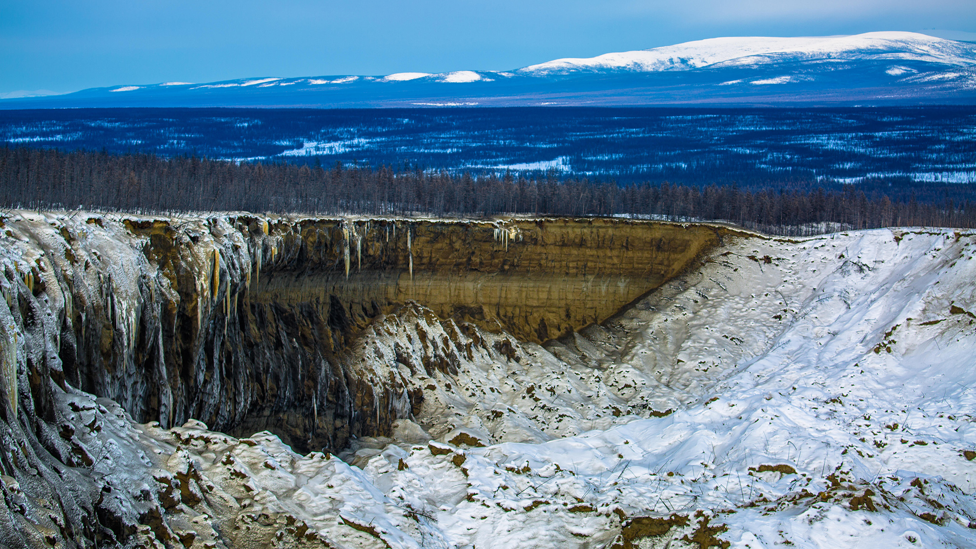
What is the Batagay Crater?
The Batagay Crater (also sometimes called the Batagaika Crater) is not a crater at all. Rather, it’s a retrogressive thaw slump (RTS) or a widening chasm caused by permafrost thaw and rapid land subsidence–basically a slow motion landslide. It’s the largest RTS in the world, and its ever-expanding size, currently sitting at more than 87 hectares (about 215 acres), qualifies it for the categorization of “megaslump,” an RFS larger than 20 hectares.
It began forming in the mid-1900’s and was first observed on satellite images from the 1960’s, says Murton. The megaslump, now “shaped like a giant tadpole,” was likely initially triggered by forest clearing and the passage of off-road, tracked vehicles moving across the delicate tundra during mineral and mining exploration, he explains. The vehicles and the clear-cutting destroyed the vegetation, which “acts as an insulating blanket, keeping permafrost cool.” With that cover gone, soil erosion swept away the top layer of ground, exposing permafrost to the elements.

Permafrost is any ground that remains completely frozen for at least two years–but much of it is significantly older than that, dating back thousands to tens of thousands of years to past glacial periods. About 15% of the Northern Hemisphere’s land is underlain by permafrost, and the northern permafrost region holds up to 1,600 million metric tons of organic carbon–twice as much as is currently in the atmosphere, according to the National Oceanic and Atmospheric Administration.
Under climate change, the Arctic is warming between 2.5 and 4 times faster than the rest of the world, and permafrost is degrading and thawing worldwide. The Batagay megaslump is one particularly conspicuous signal of that human-caused global heating.
Since it first appeared on the landscape as a narrow crevice, it’s expanded every year in a characteristic horseshoe pattern, growing fastest at the upslope headwall, where silt and soil slide away most easily, says Antoni Lewkowicz, a professor emeritus in the geography department at the University of Ottawa in Canada. As the exposed permafrost melts, the soil contained within softens into mud and collapses in on itself, flowing downstream into local waterways and rivers along with the melted ice.
And this expansion is happening fast. Between 1991 and 2018, the 180-foot-tall headwall has retreated by up to 37 feet per year and up to 98 feet in some instances, according to a study characterizing the megaslump published March 31 in the journal Geomorphology. In total, Batagay has lost 34.6 million cubic meters of material, including ground ice and thawed soil–releasing about 169,500 tons of organic carbon altogether (~4-5,000 tons each year), per the new research. These carbon estimates can help scientists better understand the climate and landscape consequences of permafrost thaw.

“Our results demonstrate how quickly permafrost degradation occurs… how dynamically the landforms in permafrost areas change,” Alexander Kizyakov, lead study author and a glaciologist at Lomonosov Moscow State University in Russia, tells Popular Science in an email. Kizyakov and his co-authors used remote sensing techniques, drone images, and soil and ice cores to come to their comprehensive and up-to-date estimates. The findings shed light on this particular megaslump, and also improve our understanding of how RTS’s evolve more generally, says Roger Michaelides, a geophysicist at Washington University in St. Louis, who wasn’t involved in the study.
Where are the other slumps?
Though Batagay’s size is stand-out, RTS formations are not rare and they’re becoming increasingly common. Thaw slumps can be found across the Arctic, particularly in parts of northern Russia, Canada, and Alaska. There’s no official count, but over the past 30 years slumps “have proliferated,” says Lewkowicz. He’s conducted years of research on Banks Island in Canada’s Northwest Territories.
At the beginning of his career in 1983, there were about 60 active thaw slumps on the island, which is about as large as Ireland. “Now there are 4,000,” he says. Over just a handful of particularly warm seasons and intense heat waves, he recalls watching the number of slumps double.
Most permafrost degradation is hidden, happening underground through a subtle and slow deepening of the active layer of unfrozen earth that sits atop permafrost. But RTSs are an especially conspicuous marker of a shifting climate and landscape. “Thaw slumps are indicators of change taking place throughout the permafrost world,” Lewkowicz says. “They’re geomorphology in action,” he adds–akin to watching waves in a storm, they’re sites where “we can actually see Earth’s surface doing something.”
In some places, the distant, existential threat posed by that change is much more immediate. Batagay is in a remote location, miles away from the nearest human settlement, but thaw slumps can occur near human infrastructure, threatening towns and transportation. In Whitehorse, Canada–the capital of the Yukon–one active slump is within sight of the Klondike Highway. “I suspect the road may need to be rerouted to avoid the slump,” says Murton.
What do thaw slumps reveal?
As they expand and release long-frozen organic carbon, thaw slumps become part of the permafrost positive feedback loop, where the carbon dioxide and methane they emit contributes to global warming. Though the volume of carbon currently being released by thawing permafrost is far less than the amount produced through the burning of fossil fuels, the permafrost contribution “is not negligible,” says Michaelides. And in the future, it could become much more significant as climate change continues. By the end of the 21st century, the greenhouse gasses released from permafrost could equal that of a large industrialized nation.
But thaw slumps aren’t all doom and gloom. They also have a serious silver lining: The geological history they reveal. Batagay offers an unprecedented look into hundreds of thousands of years of Earth’s past, exposing some of the most ancient permafrost on the planet, which is about 650,000 years old. The Siberian megaslump has provided a glimpse into past climates and well-preserved remains from extinct plants and animals–including ancient bison, horse, and mammoth bones.
And there’s likely more to come from the growing feature (though hopefully no live pathogens). At the moment, Batagay remains active, says Kizyakov. Thaw slumps can keep expanding for decades, and only stop when they reach geologic constraints. Batagay’s bottom, a sweep of rivulets and shifting silt dunes, has nearly reached the bedrock in many places, so it can’t go much deeper. But the headwall is expected to keep pushing forward. Thaw slumps will grow until they reach some topographical limit, usually the top of a slope or a body of water. Batagay still has a ways to go.